You’re on a mission. Each time you return to New Zealand, you tackle one of the country’s Great Walks. On the North Island, you’ve tramped across an active volcano on Tongariro and taken in the views from the bluffs at Lake Waikaremoana. On the South Island, you’ve hiked along Abel Tasman’s golden-sand beaches and felt like you were on top of the world on the Milford Track. You even spotted kiwis on the Rakiura Track a little farther south on Stewart Island. This time you’re going slightly off course, though.
Few people travel all the way to Great Barrier Island. Though only 60 miles northeast of Auckland, in the Hauraki Gulf, New Zealand’s sixth-largest island feels worlds away from the mainland. The 110-square-mile island is called “the barrier,” since it acts like one by protecting the capital and the Coromandel Peninsula from Pacific storms. Copper, gold, and silver were mined here in the 19th century. Kauris, New Zealand’s mighty evergreen trees, were logged through the mid-20th century. Whaling became popular after that.
Today, Great Barrier Island reminds Kiwis of what New Zealand was like decades ago. Less than 1,000 people call the island home. With no central power, generators and solar panels provide electricity. Long beaches, windswept sand dunes, and heavy waves line the open east coast; shipwrecks lie just offshore. The sheltered west coast has secluded bays and calm water for scuba diving and boating. Almost 70 percent of the island is protected as nature reserves. While the interior is full of wetlands and regenerating kauri forests, rugged hills and quiet walking tracks.
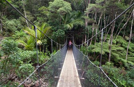
You’re heading toward Mount Hobson, the highest point on the island. Several trails crisscross Hirakimata, as the Māoris call it, but your sights are already set on the Aotea Track. It begins with a simple bushwalk to Kaitoke Hot Springs. Follow the boardwalk along the edge of the swamps, cross small streams, and search for the source of the egg smell. The sulfuric scent is rising from the damned pools at Kaitoke Creek. Listen for fernbirds and look for beautiful orchids as you soak in the hot water. Then continue along the trail to the Mt Heale Hut for views of Little Barrier Island to the west.
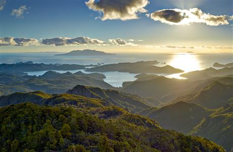
From there, the trail to the summit becomes steeper. Tall rimu and kahikatea trees line the path. The flat boardwalk gives way to staircases and swinging bridges. Rare black petrels nest high in the forest. North Island robins were recently reintroduced to the habitat. The clouds become thicker and the track becomes slipperier the higher you go. But the last push is worth it. Lush forests, hidden coves, sparkling water, and small islands are below you. The Mercury Islands, the Poor Knights Islands, and the Hauraki Gulf are in the distance. The clouds parted, just in time, to reveal the fireball sun. The Aotea Track may not be considered one of New Zealand’s Great Walks, but it’s certainly one of yours.
