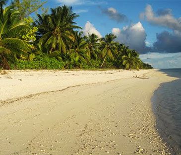
No paved roads. No running water. Electricity only a few hours each day. A jungle of emerald mangroves and coconut trees. Crushed coral and powdery white sand. Plus the velvety blue sea. You finally found a way to step back in time.
At least that’s what it feels like upon arrival on Agaléga. Two of Mauritius’ Outer Islands, the North Island and the South Island, are extremely remote. They lie 1,000 kilometers north of Mauritius—they’re actually closer to the Seychelles—in the middle of the Indian Ocean. La Passe separates the two islands. During low tide, you can walk across the exposed sandbank. Coral roads link tiny villages, the airstrip, and the little jetty on the North Island. Large ships have to dock offshore. While historical monuments—including slave dungeons, an oil mill, and two cemeteries—are scattered around Vingt Cinq, the small capital.
The islands were probably first discovered by Arab or Malay sailors, though the Portuguese claim they did in 1501. But the islands still remained uninhabited for centuries. The first settlement wasn’t established until 1808. Development only began in 1827, when the French built plantations to harvest copra and coconut oil. Malagasy people were brought in as slaves. The capital was even named after the 25 lashes given to rebellious slaves. Except for the slavery part, Agaléga still looks much like it did in the 19th century.
About 300 Agaleans live on the two islands today. They speak Creole, practice Catholicism, and work in the coconut industry. Until recently, there was no money; purchases made at the islands’ two shops were just deducted from their salaries. Crime is rare, so most people sleep with their windows open in the hot, humid climate. While visitors—traveling to see Agaléga day geckos and the view from Montagne d’Emmerez, the northern and highest point—are welcomed with fresh coconut milk, of course. They quickly find many more reasons to stay.
